
![]()
預告!
逸奇科技於 11/23~11/24 舉辦二天的訓練課程
課程將深入介紹訊號分析基本理論、常用分析方法與分享各領域實際應用案例,
歡迎攜帶NB與資料,現場提供訊號分析軟體,使您在最短時間,熟悉訊號分析概念並立刻上手實作!
有關訓練課程詳細細節 將於研討會當日公佈,敬請期待
----逸奇科技誠摯地邀請您參與----
|
預告!
課程將深入介紹訊號分析基本理論、常用分析方法與分享各領域實際應用案例, 歡迎攜帶NB與資料,現場提供訊號分析軟體,使您在最短時間,熟悉訊號分析概念並立刻上手實作! 有關訓練課程詳細細節 將於研討會當日公佈,敬請期待 ----逸奇科技誠摯地邀請您參與---- |
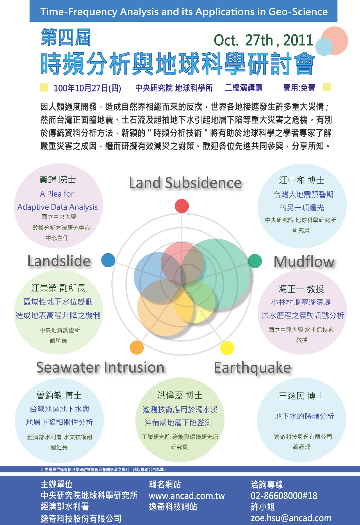
※議程
100 / 10 / 27 (星期四) |
||
時間 |
議程 |
講師 |
09:00-09:20
|
報到 |
|
09:20-09:40
|
貴賓致詞 |
|
09:40-10:20
|
A Plea for Adaptive Data Analysis |
黃鍔 院士 中央大學數據分析研究方法中心 中心主任 |
10:30-11:10
|
台灣大地震預警期的另一項曙光 |
汪中和 博士 中央研究院地球科學研究所 研究員 |
11:20-12:00
|
台灣區地下水與地層下陷相關性分析 |
曾鈞敏 博士 經濟部水利署水文技術組 副組長 |
12:00-13:00
|
午餐 |
|
13:00-14:00
|
地下水的時頻分析 |
王逸民 博士 逸奇科技股份有限公司 總經理 |
14:10-14:50
|
區域性地下水位變動引發地表高程升降之機制 |
江崇榮 副所長 中央地質調查所 副所長 |
14:50-15:20
|
茶敘 |
|
15:30-16:10
|
小林村堰塞湖潰堤洪水歷程之震動訊號分析 |
馮正一 教授 國立中興大學水土保持系 教授 |
16:20-17:00
|
遙測技術應用於濁水溪沖積扇地層下陷監測 |
洪偉嘉 博士 工業技術研究員 綠能與環境研究所 |
17:00-17:30
|
討論時間 |
|
※講題大綱節錄
黃鍔院士 中央大學數據分析中心 中心主任 Data analysis is indispensable to every science and engineering endeavor, but it always plays the second fiddle to the subject area. The existing methods of data analysis either the probability theory or the spectral analysis are all developed by mathematicians or based on their rigorous rules. In pursue of the rigorous, we are forced to make idealized assumptions and live in a pseudo-real linear and stationary world. But the world we live in is neither stationary nor linear. For example, spectral analysis is synonymous with the Fourier based analysis. As Fourier spectrum can only give meaningful interpretation to linear and stationary process, its application to data from nonlinear and nonstationary processes is problematical. And probability distributions can only represent global properties, which imply homogeneity (or stationarity) in the population.
汪中和博士 中央研究院地球科學研究所 研究員 Earthquakes occur as a result of sequential loading and subsequent release of associated stress. To understand pre-earthquake stress accumulation, we apply Hilbert-Huang transform to separate long-term plate movements, short-term seismic dislocations, and frequency-dependent (annual and semi-annual) variations from surface deformation measured by the Global Positioning System (GPS) in Taiwan. The north-south and west-east components of the filtered data are then utilized to compute the GPS-azimuths as a function of direction of surface deformation caused by loading stress in order to adapt inhomogeneous structure of strata. Results show that the good parallelization in the GPS-azimuths during the stress-loading development prior to seismic activity can be observed in 20 of 32 earthquakes in a period from 2006-2009. The leading time from the parallelization peak of the GPS-azimuths to earthquake occurrences is roughly proportional to earthquake magnitude. Relationships between the average difference of GPS-azimuths and epicentral distance are also closely examined and further utilized to locate possible epicenters before earthquakes occur. Epicenter locations of forthcoming earthquakes can be revealed with several days to weeks in advance at favorable cases. The confined areas are about 38 and 16 km away from the reported epicenters of two earthquakes (ML=6.2 and 5.8) in Taiwan, respectively. This study provides the invaluable potential in the establishment of an early warning system for future strong earthquakes. 洪偉嘉 博士 工業技術研究員 綠能與環境研究所 台灣地區過去因為超抽地下水,導致嚴重地層下陷,其中尤其以濁水溪沖積扇最為嚴重。本研究利用GPS、INSAR、水準測量與地層下陷監測井(簡稱地陷監測井)等不同監測技術組成多重感應器監測系統,分別從空中、地面與地下,不同的面向來監測彰化與雲林地區的地層下陷,其中水準測量、GPS測量與地陷監測井之測量精度控制在1公分以內,利用監測成果相互比對,發現雲林內陸地區目前主要壓縮深度發生在地層下200公尺以下。由於水準測量、GPS測量與地陷監測井皆為點狀式的測量,為快速評估大範圍的地層下陷趨勢,本研究亦應用永久性雷達干涉技術(Persistent Scatterer InSAR; PSI),使用ENVISAT衛星影像,對雲林地區進行干涉測量,經由水準測量與PSI成果比對,兩者RMSE約在0.6公分。透過研究之結果顯示,上述四項監測設備在空間解析度與時間解析度上,可相互互補以達到最佳化的監測,並提供濁水溪沖積扇的地表變形資訊。 王逸民 博士 逸奇科技股份有限公司 總經理 隨著水資源的持續匱乏,地下水源因取得容易,水質優良,已成為重要的 替代水源。而近年來因為地下水的超限利用,引起了諸如地層下陷,海水入侵等嚴重的國土問題。加上全球暖化的威脅與日俱增,降雨不均的極端氣候更使用水問題的解決刻不容緩。地下水扮演重要的水源供給角色,如何永續利用,避免災害發生,實有賴於對地下水資源的深入了解。為更進一步了解地下水的行為,有異於傳統使用模式的研究方法,本研究採用訊號分析的角度來解讀地下水觀測水位的變化,探討諸如地下水的潮汐現象,抽水行為,地層下陷的關係,與地震等重要的水資源與國土保育的議題。
|
江崇榮 副所長 經濟部中央地質調查所 副所長 地下水位起伏與地表高程變化有密切關係;然而因水文地質條件不同,地下水位升降與地表高程變化有些是正相關,有些則為負相關的,必須利用孔隙水壓與荷重兩項力之作用才能加以解釋。地下水位上升使孔隙水壓上升而有效應力下降,造成地層膨脹;地下水位面上升使蓄水量增加亦即荷重增加,造成地層之壓縮;整體之膨脹與壓縮量累計值反應為地表高程之升降。 馮正一 教授 國立中興大學水土保持系 教授
曾鈞敏 博士 經濟部水利署 水文技術組 副組長 台灣地層下陷問題,已隨著各項重大公共建設的開發,逐步引起各界的關注。政府雖已於80年代起,即推動地層下陷防治工作,並進行監測作業,然由於地層壓縮係一緩慢行為,大約於半年至一年後才會檢測出結果,致無法進行即時有效之防範作業。
|
| 時 間 及 地 點 | ||||
活動日期: 100 / 10 / 27 (星期四) ●本研討會可申請公務人員訓練時數 交通資訊 中央研究院於台北市位置圖
|
中央研究院院區總圖
|
|||
| >> TOP | ||||
| 聯絡窗口 | ||||
|
||||

